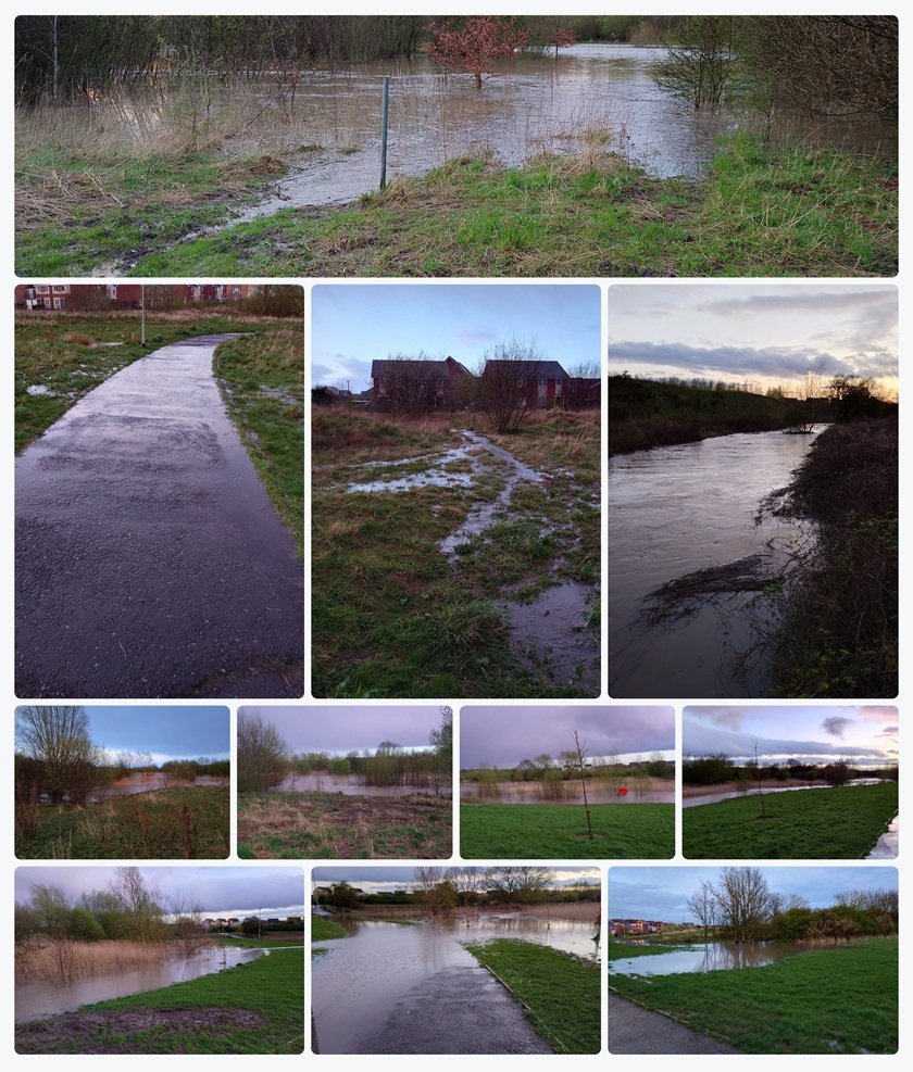
A collection of photographs taken across Newcastle Great Park on Tuesday 9 April 2024, showing the remarkable extent of flooding following persistent heavy rainfall. Green spaces were transformed into temporary lakes, trees and reed beds stood surrounded by water, and footpaths became waterlogged as floodwater spread through low-lying areas of the estate. Photographs: Great Park Gazette archive
It was an evening that many Newcastle Great Park residents will remember for the sheer amount of water covering parts of the estate.
On Tuesday 9 April 2024, persistent heavy rainfall caused widespread flooding across the North East, with Great Park among the communities experiencing extraordinary scenes.
Green spaces that residents normally enjoyed for walking, dog exercising and outdoor activities were submerged beneath large expanses of muddy water.
Footpaths disappeared into pools of floodwater, low-lying grassy areas became temporary lakes, and the pedestrian underpass beneath the A1 was so badly flooded that it could not be used safely.
Photographs taken in Great Park that evening, now revisited by Great Park Gazette, reveal the extent of the flooding and provide a visual reminder of how dramatically the landscape changed.
From waterlogged paths winding through residential areas to extensive flooding among trees and reeds, the images show scenes that looked very different from the neighbourhood's familiar green surroundings.
More than two and a half years later, they also raise questions about how well Great Park is prepared for future periods of prolonged heavy rainfall.
Tuesday 9 April 2024: The Day the Rain Took Over
The first weeks of April 2024 were exceptionally wet across parts of the United Kingdom.
A succession of low-pressure systems brought repeated rainfall, leaving the ground increasingly saturated.
By Tuesday 9 April, further heavy rain was affecting North East England and eastern Scotland.
The Met Office subsequently confirmed that persistent rain on that date caused road flooding and travel disruption, including the temporary closure of the East Coast Main Line between Newcastle and Morpeth.
Contemporary regional weather reports described more than an inch of rain falling across many locations in only a few hours.
By the evening, the effects were evident across Newcastle Great Park.
A series of photographs taken between approximately 7:56pm and 8:14pm, according to their original filenames, captured large areas of standing water.
The photographs show water spreading across open grassland, surrounding shrubs and trees, collecting along paths and covering lower-lying ground.
Although the images cannot establish the exact depth or total extent of the flooding, they clearly demonstrate that several areas of Great Park were substantially affected.
The A1 Pedestrian Underpass Completely Flooded
Perhaps the most striking photograph from the evening shows the pedestrian underpass beneath the A1.
Ordinarily, this underpass provides a route for pedestrians and cyclists beneath the busy road.
However, on 9 April 2024, the route was covered by a substantial volume of murky brown floodwater.
The photograph shows water extending across the underpass floor and surrounding the metal pedestrian railings.
The usual walking surface was no longer visible through much of the passage.
The underpass appeared impassable to pedestrians and cyclists, effectively cutting off that route until the water receded.
For residents who relied on the crossing as part of their regular walks, cycle journeys or routes through the area, the flooding was a clear illustration of how quickly severe weather can affect local access.
The photograph also raises an important question: what happens when a pedestrian route through an underpass becomes blocked by floodwater?
Unlike an ordinary puddle, floodwater inside an underpass can conceal uneven surfaces, debris and potentially dangerous depths.
Residents should never attempt to walk or cycle through an underpass when the route is submerged.
It is also important to establish whether flooding of this particular underpass has been formally assessed and whether any drainage improvements or preventative measures have subsequently been undertaken.
Great Park Gazette has not established the precise cause of the underpass flooding or whether a specific drainage defect was involved.
However, the photograph provides compelling evidence of the impact the floodwater had on the route that evening.
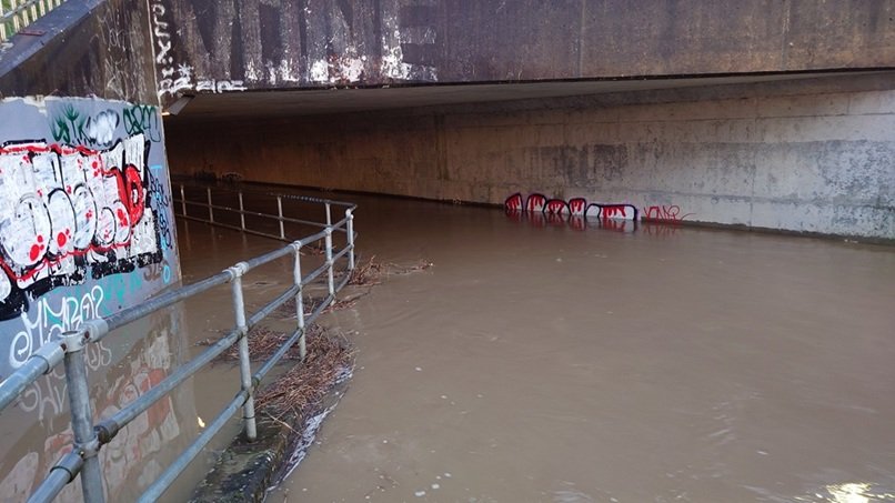
The pedestrian underpass beneath the A1 in Newcastle Great Park, photographed on 9 April 2024. Floodwater covered the route, making it unsafe for pedestrians and cyclists to use. Photograph: Great Park Gazette archive
Green Spaces Turned Into Temporary Lakes
Elsewhere across Great Park, the photographs show extensive flooding in the estate's green spaces.
Areas normally characterised by grass, reeds, shrubs and young trees had become broad expanses of water.
In some images, the floodwater stretches between trees and through reed beds, giving the landscape the appearance of a large wetland.
In others, water has spread across grassland close to residential properties.
Paths normally surrounded by green space were bordered by standing water, with puddles and overflowing areas extending across the surrounding ground.
One photograph captures a particularly wide expanse of brown water, with the tops of reeds and smaller vegetation emerging above the surface.
Another shows floodwater collecting close to the edge of a paved pedestrian path.
The images illustrate how much water had accumulated by the evening of 9 April.
For residents accustomed to walking through these areas, the transformation would have been especially noticeable.
The estate's green spaces are an important part of everyday life in Great Park, providing routes for exercise, places for children to explore and habitats for local wildlife.
The flooding temporarily changed how parts of those spaces could be used.
However, it is important to distinguish between unexpected flooding of pedestrian routes and water collecting in land that may have been specifically designed to store or manage rainfall.
Some landscaped areas within modern developments can form part of sustainable drainage systems.
These systems may be intended to hold rainwater temporarily during periods of particularly heavy rainfall.
The photographs alone cannot determine whether the affected green spaces were operating as designed or whether drainage improvements were necessary.
That would require information about the estate's drainage infrastructure and the purpose of each affected area.
The Environment Agency Had Issued a Flood Alert
The photographs are supported by contemporary flood records.
At 2:54pm on Tuesday 9 April 2024, the Environment Agency issued a flood alert covering the Ouseburn and its estuarine tributaries.
The alert warned that water levels were rising because of heavy rainfall.
It identified a risk of flooding affecting low-lying land, riverside footpaths and roads from approximately 2:45pm.
The Environment Agency expected water levels to peak overnight before falling the following morning.
Residents were advised to avoid low-lying paths and bridges near watercourses and not to walk or drive through floodwater.
The wider flood alert area included locations around the Ouseburn, including sections associated with Great Parkway, Woolsington and Gosforth.
This makes the warning particularly relevant to the wider Great Park area.
By 9:20am on Wednesday 10 April, the Environment Agency had lifted the alert, although it cautioned that standing water and debris could remain.
The official alert confirms the seriousness of the rainfall and rising water levels locally.
It does not, however, establish the precise source of the water visible at every location in the Great Park photographs.
Flooding Was Affecting the Wider North East
Great Park was not alone in experiencing flooding that day.
Across the North East, heavy rainfall and saturated ground caused disruption to transport and communities.
Regional reports from 9 April documented flooding in South Shields, while the A189 Spine Road near Blyth was closed in both directions because of severe flooding.
The East Coast Main Line also experienced disruption, with the Met Office confirming that the section between Newcastle and Morpeth was temporarily closed.
Along the River Tyne, flood precautions were being taken because of high tides and the associated risk of flooding around Newcastle Quayside.
Temporary flood barriers had been installed to protect properties.
The combination of persistent rain, saturated ground and high water levels created difficult conditions across the region.
Although high tides contributed to flooding concerns in coastal and estuarine areas, there is no evidence that tidal flooding was responsible for the water seen in Great Park.
The local photographs are consistent with the wider heavy-rainfall event recorded that evening.
Why Did So Much Water Collect in Great Park?
The amount of water visible in the photographs raises an understandable question: why did the green spaces and pedestrian routes become so heavily flooded?
During prolonged periods of rainfall, water can collect when the ground becomes saturated and can no longer absorb incoming rain as quickly as it falls.
Water may then flow across the surface towards lower-lying areas.
Natural depressions, drainage channels and landscaped areas can fill, particularly where several periods of rain occur close together.
Some modern residential developments also use sustainable drainage systems, commonly known as SuDS.
These may include ponds, wetlands, swales, basins and other landscaped features designed to manage surface water.
During heavy rainfall, certain areas can temporarily store water to reduce the speed at which it enters downstream drainage systems.
This means the presence of water in a designated storage basin is not necessarily evidence of a drainage failure.
However, flooding that makes a pedestrian route unusable raises a separate issue about accessibility and resilience.
To establish exactly what happened in Great Park, it would be necessary to review the relevant drainage designs, maintenance arrangements and any engineering investigations undertaken after April 2024.
Great Park Gazette has not verified that a drainage system failed during this event.
What the photographs do confirm is that substantial standing water affected parts of the estate and prevented safe use of at least one pedestrian underpass.
What Did the Flooding Mean for Residents?
For many people, Great Park's paths and green spaces are part of their daily routines.
Residents use them for walking, jogging, dog exercising and travelling between different parts of the development.
The flooding on 9 April highlighted how these everyday routes can be disrupted during severe weather.
When low-lying paths become submerged, residents may need to find alternative routes.
That can mean longer journeys or using roads and paths that would not normally be their first choice.
Floodwater can also present hidden dangers.
Even relatively shallow water can conceal uneven ground, displaced debris or damaged surfaces.
Flowing water may be particularly dangerous around culverts, bridges and underpasses.
For children and pets, flooded green spaces can create additional risks because the boundary between ordinary grassland and deeper water may not be obvious.
The photographs provide a reminder of why it is important to avoid flooded paths and keep away from waterlogged areas during severe weather.
What About the Estate's Wildlife?
Great Park's green spaces are also used by birds, small mammals, amphibians and other wildlife.
Periods of heavy rainfall can temporarily change these habitats, particularly where water spreads across grassland, reed beds and areas of scrub.
Some wetland habitats are naturally adapted to fluctuating water levels.
Other species may need to move away from temporarily flooded ground.
The photographs show trees, reeds and other vegetation standing in water across several locations.
However, there is no verified evidence from the images alone of wildlife deaths, damage to particular habitats or longer-term ecological consequences.
It would also be incorrect to assume that every flooded habitat was harmed.
The effects of waterlogging depend on the type of habitat, how long the water remains and the conditions for individual species.
What is clear is that the weather caused a dramatic short-term change to parts of Great Park's landscape.
Have Things Improved Since April 2024?
Looking back at these photographs also provides an opportunity to ask what has changed since the flooding.
Have there been improvements to the drainage around the A1 pedestrian underpass?
Have areas of the estate's green spaces been inspected or maintained differently?
Are residents better informed about which low-lying routes may flood during prolonged rainfall?
And are there procedures in place for warning people when an underpass becomes unsafe to use?
These are reasonable questions for the organisations responsible for the relevant roads, land and drainage infrastructure.
Responsibility may differ between individual locations depending on land ownership, adopted highways, drainage assets and estate management agreements.
It would therefore be inappropriate to assume that every flooded area falls under the responsibility of a single management organisation.
Great Park Gazette would welcome information from relevant organisations about any investigations, maintenance work or improvements undertaken since April 2024.
Why These Photographs Are Worth Remembering
Local history is not only about major buildings, planning applications or changes to the skyline.
It is also about the events residents remember because they temporarily transformed familiar surroundings.
The Great Park flooding of 9 April 2024 was one of those occasions.
The photographs capture a neighbourhood where ordinary walking routes were interrupted and areas of grassland appeared almost unrecognisable beneath standing water.
They also provide a useful record against which future changes can be considered.
As Great Park continues to develop, questions about drainage, flood resilience, green infrastructure and the maintenance of pedestrian routes remain relevant.
The photographs do not establish that the estate's wider drainage system was defective.
But they show very clearly what happened during one period of exceptional rainfall.
And perhaps the most memorable image of all is the A1 pedestrian underpass, where floodwater filled a space normally used by residents travelling safely beneath one of the region's busiest roads.
For anyone who remembers that evening, it was a striking sight.
For those who have moved to Great Park since, these photographs reveal just how dramatically parts of the estate were affected.
Have Your Say: Do You Remember the Great Park Floods?
Were you living in Newcastle Great Park on Tuesday 9 April 2024?
Do you remember seeing the water levels rising across the estate's green spaces?
Did you encounter the flooded A1 pedestrian underpass, or did the weather disrupt your usual walking or cycling routes?
Have you noticed improvements to drainage or flood management in the years since?
And are there any particular areas of Great Park that you believe remain vulnerable during periods of prolonged heavy rainfall?
Great Park Gazette would love to hear residents' memories and experiences.
If you took photographs or videos during the April 2024 flooding, you are welcome to share them for possible inclusion in our local archive, with your permission.
These photographs are an important reminder of a day when Great Park's familiar landscape changed dramatically under the weight of persistent rain.
Sources and Further Reading
Great Park Gazette photographic archive
Original photographs of flooding across Newcastle Great Park on 9 April 2024, including the pedestrian underpass beneath the A1 and flooded green spaces. An additional photograph was taken on 12 April 2024.
Met Office – Monthly Weather Report, April 2024
Environment Agency – Archived flood alert for the Ouseburn and estuarine tributaries, 9 April 2024
https://v5.riverlevels.uk/flood-warning-ouseburn-and-estuarine-tributaries/144290
Environment Agency – Flood alert lifted, 10 April 2024
https://v5.riverlevels.uk/flood-warning-ouseburn-and-estuarine-tributaries/144499
ITV Tyne Tees – Pictures show flooding brought to North East by heavy rain, 9 April 2024
https://www.itv.com/news/tyne-tees/2024-04-09/pictures-show-flooding-brought-to-region-by-heavy-rain
Government flood information
https://check-for-flooding.service.gov.uk/
Editorial note: This retrospective article is based on original Great Park photographs and contemporary weather and flood records. The exact flood depths, duration of path closures and performance of specific drainage systems have not been independently established. The article concerns the April 2024 event and does not describe current flooding conditions.

